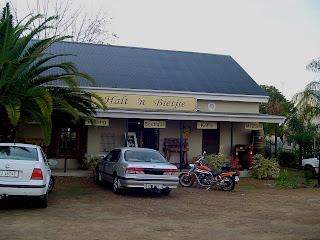
My journey started at 7.30. It was still dark, so no pictures. I rode on the backroads past Durbanville while the sun was slowly but surely sticking out its head. The weather for the day was predicted as 26 degrees with no wind. I was wondering about the 26 each time I went through a valley, but being an ex-Geography teacher I knew it would change soon. When I arrived in the beautiful little town of Wellington, I stopped for my first coffee at this little coffee shop called the "Halt 'n bietjie" (Stop a little). Although the smell of bacon and eggs tempted me to stay longer, I decided that I will have breakfast later somewhere else. I was on my way to the first pass on my journey....

Just ouside Wellington the road takes you between beautiful farmlands. With the Slanghoek Mountains in the back drop everything was green like winter in the Western Cape usually is. Being on a bike I could'n't help but smell the farms around each corner. Never though cow dung could have a nice aroma...

Thought this was somewhere in Europe? As this road is leading to one of the most dangerous mountain passes in South Africa, I was not surprized to finding hardly any cars on the road. I had the road to myself and although I wanted to make use of the "freedom" I had, I stayed under a 100kph to enjoy the morning air instead.

The top 10 km of the pass was blasted out of solid rock. An attempt was made to built a tunnel, but it fell in after heavy rains, so the road ended up being a bit longer than planned. Dacre's Pulpit seen here on the picture is a familiar site and every tourist tries to stop here to take pictures. Unfortunately there is not much space to pull over. The retaining wall, which is still standing after 150 years is still holding up the road today, does not allow for vehicles to pull over.

On my way down I took a picture while riding. I don't think riding anything faster than 50 kph is advisable, so I was basically freewheeling down when I took it. There are numerous tight corners, and some spectacular views along the road. I only crossed two vehicles on this road.

A view through one of the big boulders still remaining on the side of the road. I call it "window to heaven". Looking through the hole you can see some beautiful water falls on the other side of the valley.

When someone calls you a baboon, don't always take it as an insult. Baboons are so clever, they can break into your house and keep the police searching for the wrong suspects for years without leaving any trace that it was baboon's child responsible for the broken window and the empty refrigertor. Well, this design to safeguard the rubbish bins agains baboons seems to outsmart them.

So, if we cannot open the bloody thing, we'll use it as chairs for our beauty salon....

The next pass on my trip, just before reaching Ceres, was the Michell's Pass. Although this pass from the road does not look nearly as impressive as the previous one, it was in the heydays another engineering feat. If you stop along the road and look down you get a much better picture. With a wide road with nice curves it was a pleasure to ride this with the bike, I nearly went all the way without stopping once...

Along the road there were plenty of water falls. This time of the year sees more waterfalls due to the winter rains...and this was just one of them.

If you look at the top left side of the picture you will see the road. Just beneath it you get a glimpse of the railway line. It is suggested that one gets out of your vehicle (or down from your bike) and actually walk the railway line to get a better impression and appreciation of the magnitude of this pass. The pass has a rich history of farmers making their own roads and getting upset with other travelers using it. The first proper access was again built by Andrew Bains and it was open in 1848. This gave access to the fruitfull Ceres valley.

In Ceres, with R142 km's on the clock I filled up for my next leg to Touws River. I was not sure what to expect, so I guessed a full tank was better than a half-full one (see the optimism in that "half-full" statement?). I passed my third pass , Theronsberg Pass, just outside Ceres. From the picture one can see that it is not much of a pass, with hardly any turns and just a slight gradient downwards. I only stopped here to put my iPod on as I was ecpecting a long and dull road ahead of me....

The road to Touws River was just that...long and dull. I guess having a speed bike here would have been much more pleasurable than a cruiser. This is Karoo and somehow holds a beauty of its own...if you are into semi-dead shrubs and freaky lizards. The only living things I met here was a film crew shooting a scene in the middle of nowhere. Probably another Van Damme movie playing off 500 years after the earth was demolised by our own greediness....

In Touws River I had breakfast. I drove through the town which I visited many years ago with my parents on many of our trips down to Cape Town. There was not much left of it...but it brought back some good memories. I was on the N1 now on my way back towards Cape Town. Just before I reached the Hex River Pass, I took this picture of the Hex River Mountains covered in snow. When i got to the actual pass I decided NOT to stop as the 18-wheelers using the same route to get to Cape Town was a bit scary. There was no safe place to pull over and with the trucks using the yellow lane, I decided to drive on. When you go down the Hex River Pass you get into the Hex River Poort with a small town called De Doorns. I drove through De Doorns but again did not stop. As with the Michell's Pass you will only appreciate the pass when you take the train and hang out of the window. The first operational line was built in 1877 and is still used today.

My next stop was Worcester. Here I filled my bike and my stomach again. The riding makes one hungry I guess, as it was only 80 kms after my breakfast. Once you leave Worcester you are met by the mighty Du Toit's Kloof Mountains. At first it looks like there is no way to cross, but there are actually two ways, over or through the mountain. This picture shows the entrance to the Huguenot Tunnel, a 4 km gas chamber if you are on a bike. So I decided to do the right thing and take the pass. If you want to see how boring it is to take the tunnel, watch this clip on Youtube. http://www.youtube.com/watch?v=hRRndUwba0U

In case you are into tunnels, you might be pleased to know that the Du Toit's Kloof pass also provides a short tunnel. You can actually see "the light on the other side". In this case there were two...one being a truck. Getting stuck behind one of these trucks can really spoil your day...unless you are on a bike of course.

The reward for taking the pass in stead of the tunnel is R21 in your pocket (no toll), and the view you find on the other side. probably one of the most breathtaking views in South Africa is The Paarl Valley. When I stopped here I could feel the 26 degrees that was predicted....

On the way down form the Du Toit's Kloof pass one can see the road coming from the tunnel and meeting with the pass road just after the toll gates. Toll price being R21 for a bike nowadays I can fill a quarter of my tank with that...

Most Capetonians does not even see this anymore. This is The Paarl Mountain. The huge granite rock is formed by three rounded outcrops that make up Paarl Mountain and is the second largest granite outcrop in the world. It used to be called “Tortoise Mountain” by the Khoikhoi.

A leather couch in the making.....

The Green Green Grass of Home. The farming lands of Durbanville, with Table Mountain in the back. Now if this is not beautiful, then you are either colour blind or prefer to live in the Karoo...I drove 451 kms and it took me about 8 1/2 hours. My next trip will definately be shorter with more time to spend taking pictures and enjoying the scenery. It was fun though....
nice pics. looks like some trip. gotta love the smell of cow dung...lol.
ReplyDeleteBrian, school kids in South Africa living on farms run in winter from one heap of dung to the next to put their feet in to warm it up. Can you imagine the smell of the classroom in the mornings?
ReplyDelete