Friday, July 30, 2010

Afternoon at Eden on the Bay


Spot the whale and win a trip for two to Iraq - Take 2

We went to the beach to watch the sunset and found this.....


Thursday, July 29, 2010

I've got the power

A few months ago I wrote about my amber headlight that saved me a lot of money after a friend's suggestion to make my own. After figuring out that my Nokia XpressMusic is not only a phone, but can also function as a GPS and a mp3-player at the same time , I actually saw the benefit of using it as such. The problem with talking on the phone and listening to your favourite song while a guy with a really boring voice tells you to turn left at the next intersection, is that all this uses a lot of energy. Something my Nokia XpressMusic does not really have unless I keep charging it. So, to solve my problem I had to find a charger to do all of this on my bike. The F800GS, like many other bikes, come with a built-in power socket, but a smaller size than the common cigarette lighter you find in most cars. Finding a power plug which converts to a cigarette lighter socket was my mission for the day. After consulting the BMW website I received a couple of suggestions. This morning I went to the first shop on my list that I thought would be the one, but similar to the shock I got when I asked for the amber light cover, I had to sit down for a while to recover after hearing what it costs. Fortunately someone else suggested I make my own, which I did. This did not only save me about R250, but it also motivates me to try and make all my bike gadgets myself. Instead of feeling down because of spending money, I feel rather good now knowing that I made it myself and it is actually working. Now I can hit the road while listening to a man with a boring voice and my favourite song at the same time...


The power of a weak cold front

I have a quite a lot of sources I can consult when I want to know what the weather is going to do. My dad being one of them. He has all these theories about what the weather is going to do in Mossel Bay when the wind is blowing in Cape Town. Most of the times he is correct, because what is the difference between a few drops of rain and nothing when you are suffering from your worst drought in years. The problem is, when you are on a bike then it matters, because a few drops of rain eventually gets you soaked. Not that I am scared of rain, but as soon as it starts feeling like you are sitting with your clothes in a bucket of water, then it matters.

When I left on my gravel road trip I was aware of this approaching cold front chasing me from behind. A "weak cold front" the TV weatherman called it, with a 30% of rain. Now my dad in all his weather wisdom will tell you that 30% chance of rain is as low as 0%. When I arrived at my destination in Bredasdorp I was obviously very interested to see what the weather was going to do the next couple of days. My plan was to go to Mossel Bay, and from there up into the Langkloof and back to Cape Town. The weather prediction was still 30%, but Giel Hugo, a famous weatherman living in Bredasdorp was convinced that the next two days were going to be rather wet. I was standing in front of a huge decision. Was I going to believe that it's one of my dad's 30% chances, or do I listen to Giel the weatherman from Bredasdorp?

Early the next morning I already had my answer. I was going back home. Outside it was wet. I was not going to waste 3 days of vacation on wet weather, so I took the road back to Caledon on my way back to Cape Town. I was very reluctant in doing so, but I was worried that the gravel roads would just be mud pits and I was not planning on getting stuck for the sake of adventure, especially not if I am riding alone. From Bredasdorp all the way to Caledon I was riding in the rain. Maybe it was more mist or light drizzle, but I got wet nevertheless. Closer to Caledon I saw that the sky looked rather clear towards Cape Town, but on my left towards Hermanus and Kleinmond the clouds were hanging rather low. Besides, Giel predicted more rain towards the South Coast where I wanted to go after Bredasdorp. At Caledon I phoned my wife to ask about the weather in Cape Town to see if I should go via Kleinmond, but she never answers her phone when I need her and this time was no different. I decided to head towards Hermanus hoping that the rain was just mist coming in from the sea. With the skies clear over Cape Town, this was a possibility. The road from Caledon to Hermanus runs along the Hemel-en-Aarde Valley ("Heaven-and Earth"). This is a beautiful area and a definite place to visit on a sunny day.

A small section of the road going down to the Hemel-en-Aarde Valley
I was just about 5 kilometers from Caledon when things changed for the worst. The mist turned into a light drizzle. I never turn around, and after turning around on my whole trip I was even more determined now to take the weather as it comes. Besides, this is my only way of dealing with my disappointment of not continuing my trip. I never knew that after a while the road turns into a gravel road. Boy, was I excited when I discovered that.  Now I had no choice. I had to do the wet gravel road, there was no turning back and I was already wet. I didn't want to take pictures, was scared my camera might get wet, but at one point I did take a single shot when it looked like the rain was over. The showers were definitely scattered, with some areas looking as if it did not have any rain at all. But I was wet enough to prove that it was in fact raining. I couldn't see much of the scenery, it was too cloudy and my visor was too wet. This was probably the most tricky riding I had to do since I started my gravel road trip the day before, and at a point I stopped to feel the road surface with my boots to see how slippery it was in actual fact. I also had to switch off my ABS, something I did a few times on my trip so far. This was for sure a bonus after accepting my fate of ending my gravel road trip due to bad weather predictions. When I reached Hermanus I decided not to go back to Cape Town via Kleinmond but rather to do it across the Sir Lowry's Pass. It was clear that Kleinmond was just as wet as Hermanus. At Sir Lowry's the wind was blowing quite strong but the sun was shining. I refilled at the Shell garage near Somerset-West and arrived home about 40 minutes later, slightly drier than an hour before.

Even though my 3-day trip was shortened to one and a quarter day, I had some good riding and good experience. Getting out and on the road is just what I needed to clear my head and to give me more confidence on gravel roads. After this I realized that I should probably invest in some rain protection gear. I also discovered that my topbox is leaking and that I have to protect my contents a bit better in future. I don't know what I can do about the visor, visibility or rather the lack thereof is a serious issue. If you cannot see in front of you, how can you ride? This is another road I will do again just to get the pictures I couldn't get on this trip. I would also like it if my dad could write down his weather theories. Maybe I can publish it on my blog for future reference. But in the meantime I will make use of Giel the weatherman in Bredasdorp. No hard feelings, Dad.

Gravel Road Trip, Part 3 - (Gansbaai to Struisbaai)

There are two raods to get from Gansbaai to Struisbaai. A tarred road running next to the coast, or a gravel road going via Elim a little bit further inland. Guess which one I took? My concern for this part of the trip was that the roads might get very sandy. Fortunately the only sand I found I crossed before I even knew what was causing the "turbulence". When I executed my first proper fall a couple of moths ago it was because of sand. And this happened when I turned around because the road was getting too sandy for my liking. I was hoping that this would not repeat itself on this last section of my "gravel road trip".

Elim Moravian Church
Road to Struisbaai
From Gansbaai I basically went back towards the road I came in on, but where the tar road becomes gravel again, I headed straight on towards Baardskeerdersbos. From there it was on to Elim. Elim, like Mamre and Genadendal also has a long Moravian history. Here I also took a picture of the church, but at this stage of my trip I was more interested in reaching my destination than acting like a tourist. Or journalist as some might think. After Elim the road is tarred for a couple of kilometers until the turn-off to Bredasdorp, but I was going to Struisbaai first and this was on gravel again. It was on this section that I found some dry sandy patches. This is quite a dry area, but recent rains made some areas that were still wet slippery as well. I stopped to take a picture just to show what the surrounding landscape looked like. Very close to a Karoo landscape. Only one car passed me on this section and I didn't even take out the GPS or cell phone to see if I could get help should something go wrong. Maybe I was too worried that there might be no reception and I didn't want to know that. I did have a first aid kit with me, complete with plasters and bandages. I threw in some painkillers as well before I left. So I was OK I guess.

"Skuite" at Struisbaai harbour
L'Agulhas, the most southern tip of Africa
Stuisbaai arrived sooner than what I was expecting, or I arrived at Struisbaai sooner than what I expected. At Struisbaai I only wanted to do two things. One was to take a picture of the harbour, and the second was to drive further south to Agulhas, the southern-most tip of Africa. Here I wanted a picture of myself and my bike. I've only been here once before when we attended a wedding of friends. This is a beautiful place, but nothing much else. I cannot really say where exactly the southern-most tip is, there are so many rocks sticking out from the sea and I am sure that the tip moves as the tides change. But that is not for me to decide, besides, someone has already put up some sort indication. Many people believe that Cape Point is the furthest south, but that is not true. So the "Two Oceans Aquarium" and the "Two Oceans Marathon" that is found in Cape Town is in fact incorrect. The two oceans are split up at Agulhas. Or that is what the sign says.

After my quick stop at the Agulhas I headed to Bredasdorp on the tar road. I switched on my GPS and allowed it to take me to the address where I was staying over. A couple of minutes later I was right in front of the house. Man, I loved my day's riding and I love my GPS (when it works).

I learned quite a lot from this trip. One is that I cannot always trust a GPS and that a map is not a bad idea for a back-up. Also that some gravel roads are in fact very easy to ride, but when hitting a sand spot at 100km/h can be just as bad as hitting water at that speed. I also need to look at my GPS set-up, especially the battery charging part. I didn't run out of battery this time, but if I keep my GPS on, I might. So I need to find a charger that fits into my charger socket on my bike. I think I can make a shopping list of things I need, but I will do that at a later stage. Maybe closer to Christmas. All I know is that I had an awesome time on the road. I covered 440 km and it took me 10 hours, including all the stops. I think about 300 km was done on gravel.  I am already planning my next trip towards the West Coast. Just waiting for a friend of mine who suggested this trip. At Bredasdorp I stayed over at a cousin. What a better way to end a day's riding than with rump steak on the fire and a few cold beers.

Wednesday, July 28, 2010

Gravel Road Trip, Part 2 - (Greyton to Gansbaai)

I wasn't exactly sure where to get the gravel road that was going straight south from Greyton to the N2. All I knew was that it had to be somewhere from the town and not turnimg off from another road. That is how the map indicated it. I left the town on the opposite side that I came in and soon realized that even though this road was also gravel, it was heading towards Riviersonderend and not where I was planning to go. I was just about to turn around when I saw another road which was heading more in a southern direction. The sign said "Krige (N2)", but when I found Krige on my map, it looked more like a railway stop than a town, with no road attached to it. I was not sure if this one was the right one to take either. So this was the perfect opportunity to test my "GPS back-up system" that I worked so hard on getting set up and fixed to my bike. I took my GPS a.k.a Nokia Xpressmusic out from my pocket and searched for my currrent position. I think if I had to wait for it to tell me where I was, I would probably still be standing there. It kept "searching for GPS" and to spare it from further embarresment I eventually switched it off to rather save my battery in case I had to call for directions. I decided to take the road in any case and see where it goes, I was after all on an adventure ride looking for new roads to discover and what better opportunity than what was presenting itself right then.

A couple of kilometers down the road I came across more road construction workers and asked them if this road was going to the N2. I knew the answer already, the sign did say "N2", but still felt disappointed about the "journalist" comment earlier I decided that I need to display my lost biker image again. They didn't say anything about the bike either, but at least they didn't ask me if I was journalist. They confirmed that the road was in fact going to the N2, but there was no way that they could tell me if this was the road that I wanted to be on in the first place. What a nice road it was. Basically downhill all the way going towards the coast, quite wide and very smooth. I reached speeds of 110 km/h and probably missed most of the scenery on my way down to the N2. I was rather disappointed when I reached the N2. My initial plan was to cross the N2 and to head further south along more dirt roads. My only problem now was that I didn't know if I should go left or right to my connecting road. I took out the "GPS" again. This time I had more luck, but only AFTER I saw on a road sign that Caledon was only 15 km away to the right. This spoiled my GPS success a bit, but the fact that the bloody thing was working for a change gave me new hope. At this point I knew where I was, and the road I wanted to continue on was not far from there. Oh btw, it turned out that I was indeed on the right road from Greyton. Like my dad always says: "The gentleman who drew the map probably had never been there himself".

Finding the right turn-off again
The Klipdale road heading south
The road further south from the N2 was the "Jongensklip/Klipdale Road". I wonder why they don't indicate them like this on the maps as well? Especially if they don't have numbers like the N2 or the R62. It would make it so much easier if you knew what you were looking for. This road looked very similar to the one I've just been on. Rolling up and down over the Overberg hills all the way down to Gansbaai. Or so I thought. Some things I realized on my trip is that you can never assume that you are on the right road unless it is insidcated by road signs, that you can never think that the place will look similar to what it looks like on the map and that there are in fact more roads in reality than what is usually indicated on a map. Especially when you go to rural areas. Another thing is that on farm roads they usually don't have road signs telling you which road to take at the next crossing, and this can cause confusion of large proporsions. This information only belongs to the local farmers and their workers, which btw is a much better source than any GPS could ever be. So to cut a long story short, soon I was on another "unknown" road to an "unknown" destination. But with no farmers around  and with more confidence in my GPS now I stopped and immediately asked the GPS for directions. Bloody hell. "You are not on a road" it said. That's it, GPS is not for me. All I could do now was to turn around or continue. I never turn around, so I continued. I knew that at some point that I was going to find the road going to Standford, and that is all I needed to do to find my position again. In the meantime I was enjoying the gravel, the scenery and the excitement of "being lost".

Section of road leading to Gansbaai
Not long after I reached the Stanford road, I was ready to turn off on my last gravel section to Gansbaai. First I had some more coffee from my flask and finished my last sandwich. Although it felt to me at first as if I was going into the wrong direction, the road eventually turned south again and it felt more right. Btw, it was not the GPS that told me I was going east, it was the sun and my built-in sense of direction. Much more reliable if you ask me. This was a road with a lot of turns and up and downs...and a lot of dust. My bike was starting to look like something from Ewan McGregor's Long Way Down. The biker image was now coming through quite strong and even though I guess the image did not mean as much as the actual riding, I did get the impression that people were wondering where I've been coming from. But this time a number plate ruined my image instead of a camera.

A no-name dam close to Gansbaai
Boats for shark cage diving
I eventually reached a no-name dam but from there I could see Gansbaai and Uilkraalsmond far in the distance. I took a ride through Gansbaai to fill up and took some pictures at Kleinbaai where the brave can do shark cage diving. I have reached the end of my second part of the trip and realized that I have done more gravel road now than tar. Not bad for a "gravel road trip" in a semi-first world country.

Kleinbaai harbour with approahing cold front visible over sea

Tuesday, July 27, 2010

Gravel Road Trip, Part 1 - (Tableview to Genadendal)

Bridge over the Sonderend River
When I left home at 7 am the only thing I was concerned about is the "weak cold front" that was lying behind me. With a 30% chance of rain I guess one does not have to worry, but when you are on a bike getting "30% wet" can turn into "100% wet" very quickly. My plan was 3 days of riding on as many gravel roads as I could possibly find, and the first one was waiting for me juts after the Theewaterskloof Dam. By the time I got to the bridge crossing the Sonderend ("Without end") River, I already had my frozen bits and my coffee to recover. Yet again it was bloody cold, and I am sure now that the thermometer on my bike cannot go lower than 2 degrees Celcius. There it stops and flashes, that's all. Like the battery sign flashes on my camera when it is about to die (pun intended). I guess no-one in his right mind sits on a bike when the temperature gets colder than that, or so they thought at BMW. Unfortunately to get as many daylight hours I left early and had to deal with this my way. Getting cold is one thing, but hitting mist and getting wet as well is a completely different story, especially if you are on a gravel road that becomes slippery, you cannot see through your visor and you have no feeling in your hands left. It sounds bad enough to turn around and go home, but I needed a story and was determined to continue.

The road sign I was looking for
Gravel road between R321 and R43
Across the bridge I turned left on my first gravel road. This would take me to the Villiersdorp road going to Caledon, and from there to my second gravel road towards Genadendal. At this point my hands were completely frozen, my nose running and my visor completely fogged up. Fortunately I left the fog soon and from there on it was just cold. At least I could see in front of me again, which is rather crucial when you are on a gravel road. I was thinking back to the first time I hit gravel with my bike and realized that my confidence level was so much higher right now. Once or twice I was swinging the bike around with my body weight just to get that loose feeling on the gravel.  The road was not very wet, despite the early morning mist. So when the sun came out and I could see again I was rather surprized at the good condition of the road. But, I was there to ride gravel roads and didn't say anything about the conditions they have to be in. Here I could enjoy the scenery without having to worry too much about the road. There are some beautiful farms along this road, and towards Genadendal I realized once again what a beautiful country this is. The road runs along the Riviersonderend ("River without an end") River which passes a town on the N2 with the same name. Riviersonderend.

Gravel road towards Genadendal
Riviersonderend River
Even this road was in a very good condition, although at times there were very slippery sections. This comes from water flowing down the mountains and seeping through from the bottom. Once you hit one of these spots you can feel how snotty it becomes. There was a bit more loose gravel than the first road and at some point some construction workers were working on the road making it flat again. One can see where the vehicles have left tracks when it was wet, and these deeper "trences" in the road were quite tricky to avoid. Once your front wheel enters one of these tracks then your bike tends to follow it while your body and mind goes straight forward. This could have disasterous consequences.


Just before I reached Genadendal the road was again tarred. This didn't bother me much as I already had quite a fun ride so far. I turned off into Genadendal to go see the first Moravian church that was built there in 1738. It reminded me a lot of Mamre, also a Moravian Mission Settlement and national monument. I took some pictures of the historical buildings and were approached by an old man who said to me "You have taken pictures of all these beautiful buildings, but do you know what it was that you have taken pictures of?" I could see that the old man was about to tell me the history of this beautiful settlement starting back in 1738 and taking it through to 2010. I realized that if I don't cut his story short I will never be in Bredasdorp before the sun sets. I excused myself saying that I still have long road ahead of me and promised him that I will be back with my whole family to visit his beautiful little town again. (I promised the same to the people in Mamre a couple of months ago). He also asked me if I was journalist and I was rather disappointed that the camera made a bigger impression on him than the bike that I arrived with, especially after I've been working harder on the biker image than the photographer image. From here it was about 5 kilometres to Greytown. I drove through the town and although just as beautiful as Genadendal I never stopped to take any pictures. I wanted to be on the road again and who knows, I might visit these two towns again as I promised.

Moravian Church (1738)
No idea what this is. Should've listened to that old man

Sunday, July 25, 2010

Kids on the beach


The sad world we live in

I was paging through a magazine and stopped at the cartoon strip. I was saddened to think that this is suppose to make us smile and brighten our day, but the message here is nothing more than the hard reality we live in today. I don't want to teach my son the same, but do I have a choice...?

Saturday, July 24, 2010

Cape Garden Wild Life

I don't know if you can call it wild life, but I am sure if it does not feed from your hand then it is not domestic either. I was walking in my garden when I saw these "garden animals" and tried to take a picture or two. The reason why I say "tried" is because the results weren't what I was expecting. It was rather difficult to get the focus right and the birds (Cape White-eyes) don't seem to sit a round long enough to allow me to try more than once. The chameleon (Cape Dwarf Chameleon) on the other hand was surprizingly more accomodating, but even here I struggled to get the whole area of his rough skin in focus. See if you can spot him in the third picture.

Cape White-eyes acting like Love Birds
Soaking up the lazy Cape sun
Spot the master of camouflage

GPS back-up

OK, so I am as excited as a schoolboy going for his first sleepover at a friend's house. It is only Saturday but my bags are already packed for Monday morning. I have worked out my trip from Cape Town to Bredasdorp and then from Bredasdorp to Mossel Bay on as much gravel roads as I can possibly find. So, I am quite certain which roads to take and I know the chances of getting lost is basically zero, but don't break my spirit by telling me that. for a worst case scenario I have a map and then my new addition to my bike....my "homemade" GPS.

OK, not really a GPS, but it got me from my house to my son's school yesterday and it seemed to work. It is actually my Nokia XpressMusic with GPS software I loaded two days ago. If that does not work I can still call BMW support or even the police, but what is the fun in that? I have many concerns about my GPS, for instance that the battery will run flat before I get to my destination, or that it would get wet in the rain. But as the heading says, it is just a back-up.

Let me not discuss the shortcomings of my GPS right now, I know this will become very clear as soon as I am forced to start using it. Let me rather point out how innovative I was in attaching it to my handle bars. I happened to have brackets which were supposed to solve my previous hand guard problem. Fortunately a friend of mine was just as innovative and fixed that for me by heating the bracket and bending it to fit. Thanks for that, Roodt. So, with the unused brackets and a cell phone pouch that I received with my phone, I managed to improvise a cellphone/GPS/mp3 player (a.k.a my Nokia phone) holder to my handle bars. The pouch I never could really figure out what it was for, because once you have your phone inside it you could not press ANY buttons. So I cut the front part out which looked more like some sort of speaker cover, attached the pouch to the handguard bracket and Voila! My own GPS. The nice thing about this bracket is that when I grow up and get a real GPS that I could easily convert it to attach my real GPS bracket to it. But, as long as I am riding IN Africa and not ACROSS Africa I am sure this will do for now. Besides, I will keep my phone protected in my jacket pocket until I am really lost and forced to take it out. Why would I expose my phone to all the possible onslaught from the elements before I really need to in any case? Below are some pictures to illustrate. I know I screwed up with the carpet knife on the right hand side, but hey, this is Africa and we don't follow fashion, we just try to survive.


(And if all else fails, then I will just use it to listen to my mp3's......)

Thursday, July 22, 2010

"Tussen de Liefde en de Leegte"

If you don't understand Dutch then I guess these words won't mean anything to you. I was trying to translate it to English and although it is easy to understand "liefde" (love), I could not find the best description for "leegte". "Emptyness" maybe? In the context of this I would rather say "what I cannot find". Well, before I try and figure out what the best word for "leegte" is, let me tell you where this comes from.

Many years ago a Belgium singer called Stef Bos discovered South Africa. At the same time many South Africans discovered Stef Bos. One of his early songs was called "Tussen de Liefde en die Leegte". We all became Stef Bos fans because for once there was a singer that could put more feeling and meaning into a song than most of the upcoming Afrikaans artists at that time. I mean, what the hell can "My Rooirokbokkie" (My chick with the red dress) possibly say other than that we have some of the most common and shallow singers in the world? At first I didn't pay much attention to the words, but one day my wife told me that this is probably one of the best songs ever to describe my/our situation. Only then did I realize that I have a "problem" and that other people around me feel it too. I never saw it as a "problem" before but I guess for some it might be. I know it used to be a problem for my mother. She thought that there was something wrong with me because I could never sit still for one minute. She called it "rooimiere" (red ants). If you are ever in South Africa and get red ants in your pants you will know what it means. Anyway, I was always on my way somewhere, looking for something exciting to do, something new to discover, never knowing what I am hoping to find. If I had to sit and wait for 10 minutes it would freak me out. "Impatient" my mom would often call me but "a waste of precious time" I would think.

After 42 years I still have not found out what the real reason behind my "search for something" is. After getting a bike 4 years ago I was so scared that it might be a mid-life crisis thing. When I read books about guys quitting their jobs and buying bikes, it seemed that they were all at the age where I am now. Fortunately for me I have a history of "quiting my job" and "buying bikes" and for me it started when I was still in my teens. I am 42 now and I am still "quitting jobs" and "hitting roads". Why? I have no answer. What am I searching for? No idea either. What I do know is that I might have struggled with a "mid-life crisis" ever since I've been a teenager and that this is just a continuation of my journey to that "leegte" (emptyness) where I hope to find rest at last. Or maybe I am just enjoying life (at the cost of my loved ones of course). I think this is why this song is so relevant. I always have this fight in me. I want to be home with my family (de liefde), but I cannot wait to get out and discover new things and places (de leegte).

My wife has given me permission yesterday to take the bike and explore some new roads despite the fact that I have been to Scotland not so long ago and already busy planning my next trip into Africa. But I need to get out, because I am driving her insane and I am going insane. I think by now she knows that I will always come back so she is letting me go knowing that after a couple of days I will be missing them too much and return. Until the next time of course. But keep watching, I will write about my trip as soon as I have a chance.

I have translated the words of the song hoping I could explain the essence of it without losing the meaning it has for me. Hope it makes sense...

Ik blijf mijn hele leven reizen
(I keep my whole life traveling)
Ik volg de wegen van de twijfel
( I follow the roads of doubt)
Ik zoek naar wat ik nooit zal vind
(I'm searching for what I'll never find)
Want ik wil dwars door de dood heen zingen
('Cause I want to sing across the end of life)
Ik wil proberen iets te maken
(I want to try and do/make something)
Ik wil niet breken, ik wil niet haten
(I don't want to break down anything or hate anyone)
Maar op zoek naar mooie woorden
(But while searching for better words)
Heb ik de liefde vaak verloren
(I have lost love so many times)
Ik ben altijd onderweg
(I've been always on my way)
Ik leef onrustig en onzeker
(I live restless and uncertain)
Tussen de liefde en de leegte
(Between what I love and what I'm searching for)
Dit is geen leven om te delen
(It is not life if you have to share)
En toch is heel mijn hart by jou
(But still my whole heart belongs to you)
Maar laat me niet teveel beloven
(But let me not promise too much)
Want ik blijf m'n dromen trouw
(because I only stay true to my dreams)
En ik wil nog zoveel woorden zingen
(I still want to sing so many songs)
Het is een passionele drang
(It is a passionate urge)
Ik wil alleen En alleen bij jou zijn
(I just want to be with you)
Maar ik vind nooit de balans
(But I can never find the balance)
Dus ik blijf altijd onderweg
(Therfore I am always on my way)
Ik reis onrustig en onzeker
(I travel restless and with uncertainty)
Tussen de liefde en de leegte
(Between what I love and what I'm looking for)

Aan my vrou...
Dankie dat jy verstaan en my laat gaan. Ek kom weer terug...

Wednesday, July 21, 2010

To a funeral via the scenic route

I don't really have the money now for a new GPS so I bought myself the cheaper version instead. A 1: 325 000 map of Cape Town and Surrounding Attraction, 3rd edition. There is something to a map that you don't find with a GPS. It is like reading a newspaper from the Internet. That feeling and smell of the newspaper in your hands just disappears when you try do do it electronically. The same goes for finding your way through some unknown territory with the help of a GPS instead of a map. I remember once I was traveling through the Sahara with a convoy led by a guy that really knew his way around in a place which to me just looked like u huge beach with no sea. When we stopped to have a drink, I asked him where we were. Instead of giving me some coordinations from his GPS, he took out a map and opened it on the bonnet of his 4x4. Apart from the fact that it was probably the closest I ever came to feeling like Indiana Jones, it was much easier to orientate myself in case I had to continue walking from there. GPS coordinations would not have helped. Anyway, so I got the map and what better way to try it out than going to a funeral via the scenic route.

Yes, I went to a funeral of a cousin which I didn't really know. I believe that the rest of the family always appreciates the support more than the deceased, but at the funeral I was thinking that by being there I might've increased the chances of actually having someone at my funeral one day as well. If you ever get time to watch the movie "The Big Fish", then you will know why I would love to have plenty of people at my funeral but that's another topic for later. I am sure I can write many posts about funerals, but I will leave that for a day when I have not seen the heartache of people seeing off a deceased loved-one as recently as yesterday. So, I was on my way to a funeral with my bike and a map. The nice thing about living in a more developed country is that there is usually a well developed road network. The problem with living in a more developed country is that most of these roads are usually tarred. I am more interested in the gravel roads. My new map shows more detail  on gravel roads than my previous Road Atlas so thought I might as well take the scenic route to the funeral and back. Not that I don't have any sympathy with the deceased or the family, but I have learned that if you cannot turn an "uncomfortable" event into an "acceptable" one, then you might as well give up on life too.

Road towards Du Toits Kloof Pass
Disgruntled family members
My trip to Worcester started very early. My plan was to go straight on the N1 across the Du Toits Kloof Pass to Rawsonville, which is close to Worcester. According to my map this is where I could find some interesting undiscovered (for me at least) gravel roads. From my start I had to endure the same cold temperatures I had on Sunday, so going to 3.5 deg C was not a good start for me. When I approached the Du Toits Mountains I was thinking of chickening out and going through the Huguenot Tunnel, but as I was climbing the pass, strangely enough so was the temperature. In my head I was paging around through my old climatology text books that my dad so dearly paid for in an effort to give me an education trying to unravel this strange phenomenon. I eventually came to the chapter on anabatic and catabatic air flow and figured out why. The temp at the top climbed to 16 deg C, but as expected on the way down it went down with me. Just after the small tunnel at the bottom of this pass, I met a few other relatives of mine. Babboons. I stopped to take a family picture but they were not interested, typical of family that you have neglected over the years.

By the time I got to the Rawson turn-off, I was back to nearly a frozen state. The temperature was around 4 deg C. My first gravel road was up Holsloot to the Limiet Berg Nature Reserve. Here I was not only hoping to find a nice gravel road leading up to the reserve, but also checking for any future camping possibilities. To my disappointment the road was closed, with plenty of signs advising NOT to enter. My first gravel road for the morning was a dead-end. A little bit less motivated now due to the temperature effect on my state of mind, I headed for my second road I was planning to do before the funeral. This road, according to my new map, runs around the Bergvlei Dam where it meets up with the Villiersdorp to Worcester road. From there it would be an easy ride to get to Worcester and in time for the funeral.

Bergvliet dam
Bergvliet dam
I was impressed with the size of the Bergvliet Dam as I was heading towards this gravel road. I stopped to take a few pictures of the dam with the sun rising on the opposite side, hoping that the temperature would also rise soon. By now it was around 7 degrees and climbing. A sign next to the turn-off saying "Bergvlei Correctional Services" didn't bother me much, but when I came around a corner and saw huge gates with guards, it did. I stopped to ask what the hell was this in the middle of the road that I am about to take around the dam, and was informed that this was in fact the road leading to the prison, and unless I arrived there for work or in the back of a police van, then I have no business there. Another dead end for me, at least not as permanent as for so many on the opposite side of that fence, but still. By now the motivation was completely lost so I went straight to Worcester two hours early to find the church where the sermon was going to take place. For comfort and to get my blood flowing again I stopped for a breakfast and coffee at the Wimpy.

Theewaterskloof dam
One thing that really caught my attention at the funeral service was the way the deceased were described by the family. A man that was totally obsessed with nature and hunting. I was wondering what people would say about me at my funeral one day. A man that was totally obsessed with the pleasures he could get out life, or someone maybe who could never find the gravel road experience he was obsessed finding? While I sat there I once again realized that time is short and we have to make the most of life while we can. I was sure that my cousin would not have raised an eyebrow if he heard that I took a scenic road to his funeral, so I decided there and then that I will continue my scenic trip back to Cape Town.

More Theewaterskloof Dam
From Worcester I went to Villiersdorp but decided I will skip any more gravel roads and just head back to get back to work. The road is not much longer than the N1, but it has more curves than a California beach babe and with lots of picture opportunities. From Villiersdorp I took the Franschhoek Pass road towards Franschhoek. First I took some pictures of the Theewaterskloof Dam just to show that I was there, and also stopped at the famous lookout point on top of the pass. The Franschhoek Valley that lay in front of me is nothing new to me. I have seen that valley from various heights before. This is a very famous paragliding spot and I used to fly there quite often. But today I was on my bike and I was now in a hurry to get back to work (yeah, I know it sounds like bullshit but I was).

Back of Franschhoek Pass
Franschhoek pass

The couple of kilometres on the N1 back to my office gave me enough time to reflect on my day of  "dead ends". Despite the fact that I was going to a funeral, despite the fact that I reached some dead ends myself, the day turned out to be another exciting one. I have not given up on finding that ultimate gravel road yet, and like the cliched saying says about life, the journey towards the destination should never be ignored. Today was just another stop on my way to find that ultimate road....


Franschhoek Valley

One man's trash is another's treasure

The environmentalists and aestheticians might be up in arms over the stranded Seli 1 at Kite Beach. Some claim that it "contaminates" the beautiful view of Table Mountain. Even though most surfer's are usually also very aware of the protection of the environment and coastlines, as much as the beauty thereof, they cannot deny that the Seli 1 is bringing them more pleasure than pain at the moment. For a spot where surfing was never really done due to the inconsistency of waves and the poor shape of the waves, for a day where the rest of the ocean was for all practical reasons unsurfable, this was not too bad. This has also become a favourite spot for SUP's (stand up paddle boards). Behind the protection of the ship they can basically paddle in without having to dodge any waves and then just move over to the side where they can catch some really long mellow rides.


Spot the whale and win a trip for two to Iraq


I took this photo which consists of 80% water, 19% land and 1% whale at Bloubergstrand over the weekend. You can read more about the whales that visit South African shores on Wikipedia if you are really ineterested in knowing anything about them. If you are interested to know WHERE you can see them from really close up without having to pay someone for an expensive boat ride, don't think that Hermanus which is famous for its whale festival and wave caller is the place to go. If you contact me directly I can tell you about this secret spot along the South Coast where the whales are litterally a stone's throw away from the coastline. But please do not throw stones at them, just enjoy their presence. In the meantime you can go watch the movie Whale Rider to get the feeling....

Sunday, July 18, 2010

My 67 minutes of charity

The call was made to every South African to donate 67 minutes of their time towards some sort of charity in order to commemorate Nelson Mandela Day. To promote this a bunch of celebrity "wannabe bikers" would ride all the way from Johannesburg to Cape Town and get involved in some community projects on their way down to the Mother City. The last stretch would be from Franschhoek going down to the biggest black township in the Western Cape, Khayelitsha. Here they would contribute by "putting up a fence" to show their involvement and to motivate others to adopt the same attitude. So this is where my story starts....

After seeing an invitation from the Cape Town BMW Motorcycle Club to join these celebrity bikers from Franschhoek to Khayelitsha, I decided that this was the perfect opportunity for me to pledge my 67 minutes while having fun at the same time. I was a bit scared that I might have to dig sewage trenches or build schools, but putting up a fence could not ruin my motorbike attire too much and I was happy to go along. Getting a bike ride as part of the deal was an opportunity not to be wasted and a bonus. I was hoping that my wife would come along, but she had recently decided that "putting all our eggs in one basket" on a bike while we have a 3-year old son was not a good idea anymore. "What would happen to him if we don't survive a crash or something?" So to have some company I had to find another pillion fast. Besides, the more hands we had to erect the fence, the less work for me I reckoned. My new pillion, which happened to be one of my friend's "eggs", was more than willing to cruise along. She claimed that she had her "pillion training" many years ago on speed bikes, but she soon realized that there is quite a difference between a speed bike and a dual purpose semi-offroad like my 800 GS. Speed bikes are for real men with more balls than brains, while my rugged looking semi-offroad macho machine is more for real men with balls as well as brains. Being a pillion on these different types of bikes differs quite a lot, but she was a fast learner and got the feel for the more adventurous bike pretty quick. This time she only had to sit still and enjoy the scenery. But this she would only figure out a little later on the trip.

My charity actually started at around 7.25 when I collected my pillion from her house. By providing some additional biking excitement to my passenger I was for sure in for more than 67 minutes of "charity" for the day. The meeting point for the bikers (the real ones) was 8am at the N1 Engen garage. On our way there the temperature dropped to 6 deg C and I could see that I might lose my pillion if we didn't stop for coffee soon. When we arrived at the Engen meeting point we were told that we should be moving on, so no time to defrost and no time for coffee either. On our way to Franschhoek we hit temperatures of 3 deg C and at 130 km/h it can get rather chilly. We all managed to reach Franschhoek without looking like popsicles and fortunately for us there we had time for a cup of coffee and a muffin. After that we departed to meet the fancy wannabee bikers at a posh estate just outside Franschhoek.

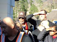
When we arrived at the hotel the celebrities were still picking bacon from their teeth after their full English breakfast. One of them was none other than Madiba's stunt double from the movie Invictus, Morgan Freeman. It was clear that they had a good night's sleep in this 5-star hotel where the rooms could easily go for R1500 per person per night sharing. If I had known that doing charity was such an luxurious affair I would've opted for the whole week in stead of just 67 minutes, but I guess I don't have celebrity status yet and would not have qualified for the team. Of course the media was on time as well and when Mr Freeman showed his face outside for the first time I wondered if anyone were really thinking about the poor kids in Khayelistha at that moment. I also forgot about them for a while and tried to get some pictures myself without being too obvious about doing it.

At 9.30 we were ready to leave in a well structured convoy. We were told that the celebrity wannabee bikers would ride in front, then a flashy BMW with Mr Freeman as occupant behind them, and then the real bikers would follow suit. The explanation was that the wannabee bikers were scared that the real bikers would go too fast and make them nervous on the road. This was just a bunch of bullshit of course. They didn't want to mix the elite with the riffraff. So, off we went, about 40 bikers on their way to do charity work in Khayelitsha. All of us on bikes worth R100 000 or more and Mr Freeman in his R850 000 7-series BMW. What a way to get our hands dirty for charity...

Needless to say, the ride to Khayelitsha was awesome. All bike rides are usually awesome. We went from Franschhoek through Stellenbosch along the most beautiful roads and scenery. The traffic officers stopped all traffic and allowed us to cross red lights and disrespect speed limits. With the Beemer in the middle, 8 traffic officers on motorcycles in front and the 20 riffraff "bodyguards" following, I couldn't help but feel like a VIP escort for some Head of State in Africa. Presidential convoys are so typical of Africa and this one had the same pretentiousness. My pillion at this point realized that she could release her claws from my jacket and that we could actually go around corners without having to touch the tarmac with our knees. She took out the camera and started taking pictures like a chinese tourist on her first trip to the Kruger National Park. She got so carried away with the pictures that at some point I had to turn around to see if she was still on the bike.

Now this would not only have been my first time in Khayelitsha, but also my first time in a black township. I don't know why the old regime planned the black townships in such a way that it feels like once you're in you can never get out again, but I guess it added to the excitement. Khayelitsha was no different. You can drive in circles going deeper and deeper with the prospects of ever seeing your family again seemingly getting smaller and smaller. This was probably my biggest concern, how to get out once I'm in. But with a group of 40 bikes, Mr Freeman in his BMW and all the staff from the local police stations on duty alongside the roads, I was not worried at all. Today I was going to erect a fence in 67 minutes flat, and then I'm going to negotiate my way out again and feel proud of myself. I was rather disappointed when we came closer to the spot where the rest of Cape Town's media and some other high profile celebrities were already waiting. The area was cordoned off and the poor people whose lives I was about to change were nowhere to be seen. All that we found was a plot of land belonging to some charity organization with a section of a fence in the middle of nowhere, half way erected already. All that was needed was for someone to attach the upright slats with some bolts and a rachet socket. Not nearly blisters-on-your-hands kinda work at all, and nothing that would further ruin my bike jacket with the recently acquired claw marks. Only then I realized that erecting this fence which didn't really fence off anything was nothing more than a publicity stunt. With camera's clicking Mr Freeman nonchalantly walked towards the fence while someone was already holding one of the slats to be tightened. With one hand in his pocket, he lifted the rachet socket and while smiling at the camera he made a few dummy turns. This was done with a spanner that was shining brighter than the beemer he had arrived in. Nor he nor the socket spanner has ever done more than 67 second's worth of hard labour before, let alone 67 minutes of it. I was still taking pictures of Mr Freeman when somebody mentioned that the Western Cape Premier, Mrs Helen Zille, was also helping at that stage. I wouldn't even have noticed her if someone else hadn't point her out to me. Not only is she too short to pose next to Mr Freeman on the same portrait, but she was pretending to tighten some bolts lower down on the same slat somewhere around the height of his waist. I was too disgusted to take any pictures of her effort and rather went for a much needed wee in one of the temporary mobile toilets that were shipped in especially for this occasion. That was probably the only toilet in Khayelistha with running water at that time, and I am pretty sure they didn't leave it there after the theatrical procedings were done for the day. The ANC Youth League has a history of destroying toilets that were not built with solid bricks.


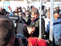
I looked at the spectacle of VIPs trying to look all interested in doing their bit for the community, the dozens of photographers trying to get the best shot for their morning paper, the real bikers watching the organized choas form a slight distance and the clear absence of hungry black faces benefitting anything from this exercise. I looked at my hands that have never done any hard work for anyone that I could be proud of and wondered if I was just as fake as these people with all their money and riches. There are so many people that have sacrificed their lives to help the poor and needy, and here we were with our shiny bikes and flashy cars trying to look important. I asked myself what did I contribute today, and I couldn't think of anything. Maybe I didn't contribute to this event at all today, but it stopped me for about 67 seconds to reflect on myself and what I have. Whether I was previously "advantaged" or not, whether I worked for what I have or not, I was fortunate to be there, to have what I have and to live the life I live. I was wondering what I could do to give something of myself to the poor. Not to gain anything by doing it, but to do it as a way of showing my appreciation for what I have. Who cares if this whole exercise was just a show or not, it opened my eyes. It made me think. If this was the objective and one person today was made aware of how much his support and contribution could mean to others then the objective was achieved. How many more did experience what I have experienced today. Together we can all make a difference, if we are only willing to put aside the much needed time. I am sure I will find another 67 minutes to do something more substantial than what I did today and that many others would do the same.

Happy Birthday Madiba.