I wasn't exactly sure where to get the gravel road that was going straight south from Greyton to the N2. All I knew was that it had to be somewhere from the town and not turnimg off from another road. That is how the map indicated it. I left the town on the opposite side that I came in and soon realized that even though this road was also gravel, it was heading towards Riviersonderend and not where I was planning to go. I was just about to turn around when I saw another road which was heading more in a southern direction. The sign said "
Krige (N2)", but when I found Krige on my map, it looked more like a railway stop than a town, with no road attached to it. I was not sure if this one was the right one to take either. So this was the perfect opportunity to test my "
GPS back-up system" that I worked so hard on getting set up and fixed to my bike. I took my GPS a.k.a Nokia Xpressmusic out from my pocket and searched for my currrent position. I think if I had to wait for it to tell me where I was, I would probably still be standing there. It kept "
searching for GPS" and to spare it from further embarresment I eventually switched it off to rather save my battery in case I had to call for directions. I decided to take the road in any case and see where it goes, I was after all on an adventure ride looking for new roads to discover and what better opportunity than what was presenting itself right then.
A couple of kilometers down the road I came across more road construction workers and asked them if this road was going to the N2. I knew the answer already, the sign did say "N2", but still felt disappointed about the "journalist" comment earlier I decided that I need to display my lost biker image again. They didn't say anything about the bike either, but at least they didn't ask me if I was journalist. They confirmed that the road was in fact going to the N2, but there was no way that they could tell me if this was the road that I wanted to be on in the first place. What a nice road it was. Basically downhill all the way going towards the coast, quite wide and very smooth. I reached speeds of 110 km/h and probably missed most of the scenery on my way down to the N2. I was rather disappointed when I reached the N2. My initial plan was to cross the N2 and to head further south along more dirt roads. My only problem now was that I didn't know if I should go left or right to my connecting road. I took out the "GPS" again. This time I had more luck, but only AFTER I saw on a road sign that Caledon was only 15 km away to the right. This spoiled my GPS success a bit, but the fact that the bloody thing was working for a change gave me new hope. At this point I knew where I was, and the road I wanted to continue on was not far from there. Oh btw, it turned out that I was indeed on the right road from Greyton. Like my dad always says: "
The gentleman who drew the map probably had never been there himself".
 |
| Finding the right turn-off again |
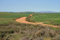 |
| The Klipdale road heading south |
The road further south from the N2 was the "Jongensklip/Klipdale Road". I wonder why they don't indicate them like this on the maps as well? Especially if they don't have numbers like the N2 or the R62. It would make it so much easier if you knew what you were looking for. This road looked very similar to the one I've just been on. Rolling up and down over the Overberg hills all the way down to Gansbaai. Or so I thought. Some things I realized on my trip is that you can never assume that you are on the right road unless it is insidcated by road signs, that you can never think that the place will look similar to what it looks like on the map and that there are in fact more roads in reality than what is usually indicated on a map. Especially when you go to rural areas. Another thing is that on farm roads they usually don't have road signs telling you which road to take at the next crossing, and this can cause confusion of large proporsions. This information only belongs to the local farmers and their workers, which btw is a much better source than any GPS could ever be. So to cut a long story short, soon I was on another "unknown" road to an "unknown" destination. But with no farmers around and with more confidence in my GPS now I stopped and immediately asked the GPS for directions. Bloody hell. "
You are not on a road" it said. That's it, GPS is not for me. All I could do now was to turn around or continue. I never turn around, so I continued. I knew that at some point that I was going to find the road going to Standford, and that is all I needed to do to find my position again. In the meantime I was enjoying the gravel, the scenery and the excitement of "being lost".
 |
| Section of road leading to Gansbaai |
Not long after I reached the Stanford road, I was ready to turn off on my last gravel section to Gansbaai. First I had some more coffee from my flask and finished my last sandwich. Although it felt to me at first as if I was going into the wrong direction, the road eventually turned south again and it felt more right. Btw, it was not the GPS that told me I was going east, it was the sun and my built-in sense of direction. Much more reliable if you ask me. This was a road with a lot of turns and up and downs...and a lot of dust. My bike was starting to look like something from Ewan McGregor's
Long Way Down. The biker image was now coming through quite strong and even though I guess the image did not mean as much as the actual riding, I did get the impression that people were wondering where I've been coming from. But this time a number plate ruined my image instead of a camera.
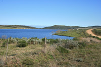 |
| A no-name dam close to Gansbaai |
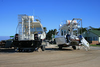 |
| Boats for shark cage diving |
I eventually reached a no-name dam but from there I could see Gansbaai and Uilkraalsmond far in the distance. I took a ride through Gansbaai to fill up and took some pictures at Kleinbaai where the brave can do shark cage diving. I have reached the end of my second part of the trip and realized that I have done more gravel road now than tar. Not bad for a "gravel road trip" in a semi-first world country.
 |
| Kleinbaai harbour with approahing cold front visible over sea |


No comments:
Post a Comment